
The Upper Applegate Fire Hampered by Illegal Drone
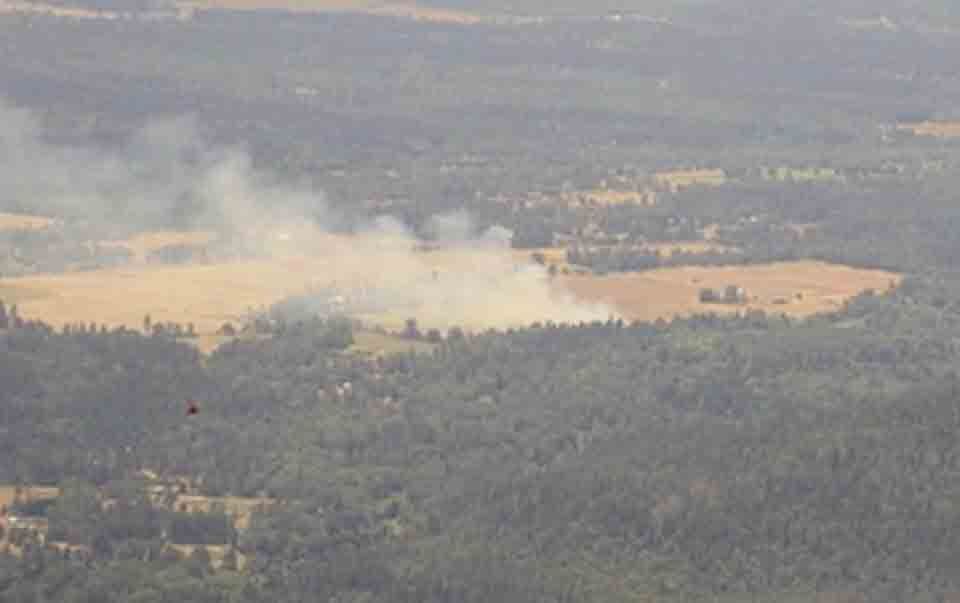
JACKSON COUNTY. Ore. — As firefighters continue an exhausting fight to contain more than 500 acres of steep terrain in Upper Applegate, the Oregon Department of Forestry (ODF) says it is continuing to search for the person responsible for launching an unauthorized drone above the flames.
UPDATE: The Upper Applegate Fire Has Spread Another 256 Acres But Is Fully Contained
Jackson County Sheriff Deputies and Firefighters Seach for Drone Operator
In a statement on its Facebook page, the ODF says it had to shut down the use of aircraft flying over the Upper Applegate Fire last night. ODF says drones can cause fatal accidents and the department was not prepared the risk the safety of its pilots and firefighters.
The ODF states that the Jackson County Sheriff’s Office (JCSO) deputies and firefighters are searching for the operator of the drone in an ongoing investigation. Anyone with information is asked to call the JCSO Tip Line on (541) 774 8333.
Resident Praises the Skill, Precision, and Bravery of Firefighting Pilots
Responding to the ODF statement, local resident Hadley Rose de Terre says she cannot understand why anyone observing the fire would think that flying a drone overhead would be a good idea. De Terre, who lives directly opposite the area from which helicopters and tankers are stationed, praised the firefighting efforts, saying “we are so grateful for all of our dedicated firefighters and beyond impressed with the skill, precision, and bravery of the pilots.”
Fire Update at Time of Going to Press
At the time of going to Press, good progress was made to contain the 500 acres in the Upper Applegate Fire. The fire is situated south of Ruch, an unincorporated community of 840 people located on Route 238, Oregon, southeast of Grants Pass. The Upper Applegate Fire includes property owned by the Bureau of Land Management (BLM), the Rogue River-Siskiyou National Forest, and the U.S. Forest Service (USFS).
The secondary fire, known as the Highway 62 Fire, is south of Shady Cover and contained within a 75-acre radius. It is 100% lined and 20% mopped up.
Steep and Rocky Terrain and Dead Trees are Slowing Progress
Last night, resources continued to work on mop up operations, but the top priority remains the Upper Applegate Fire. By late yesterday afternoon, firefighters had built an indirect line around 70% of the fire perimeter, and a 10% direct line at the fire’s edge. But, according to the ODF, steep and rocky terrain, combined with hazardous snag trees, are slowing progress.
The ODF says there are “significant patches of dead Douglas fir trees” which tree fellers were working to remove. This would allow firefighters to work closer to the perimeter of the fire.
Despite hot and windy conditions, overhead firefighting played a key role in containing the flames. Although aircraft had to be recalled from operating last night because of the overhead drone, earlier in the day one Very Large Air Tanker and three federal Large Air Tankers helped fight the fire, using retardant to create temporary fire lines. The ODF says this operation helped to contain the fire’s footprint.
Residents Alerted to BE READY for Evacuation
Last night, firefighters concentrated an establishing a direct line along the eastern border of the Upper Applegate Fire and continued to protect a dozen nearby residential dwellings. This aspect of the operation will remain a priority. BE READY evacuation notices have been issued by Jackson County Emergency Management and the Jackson County Sheriff’s Office. The Jacksonville areas affected are:
Zone JAC-436: Applegate Road, west of Upper Applegate Rd. And the eastern portions of Sterling Creek Rd.
Zone JAC-434: Eastside Road, south of Little Applegate Rd. North of McKee Bridge.
Yesterday, more than 100 personnel worked on the Highway 62 Fire and evacuation notices issued for Zone JAC-164 were lifted.
Hot weather and wind are expected will fuel the flames today and firefighters have prepared for these weather conditions.
For more information about locations and zones contact: genasys HYPERLINK “https://protect.genasys.com/search” Protect HYPERLINK “https://protect.genasys.com/search”. Readers can also contact the ODF website at: https://swofire.com/